
Archaeological Exploration and Survey
In
Southern Inyo County, California
by
Clifford Park Baldwin
1931
Excerpt.....
Swansea Group
Provisioning was all attended to October 30, 1931. We left early Sunday morning for a point at the foot of the Inyo Mountains on the northeast side of the Owens Lake. This we have marked on the Ballarat Quadrangle, about 4 miles northwest of Keeler. Here we sketched and photographed this large group of petroglyphs that are in danger of being obliterated by quarrying activities, marked no. 1 on the topographical map. Plate 8 gives a view of the site with the quarry at the extreme left. Huge rocks are flung high into the air, descending on the petroglyphs and badly chipping them. In the foreground can be seen a white marble metate. Surrounding it we found numerous potsherds, one brown point and a small fragment of shell, probably part of a pendent from the coast. This fragment and others we found at Independence seem to indicate much trade.
We were told there was a rock mortar at this site, but plate 9 is a picture of a pot-hole we found that measured 14 inches across and 18 inches deep.
That and a metate shown on plate 11 are all we could find. This plate shows petroglyphs on the surface of the rock was without a doubt as a metate by a later people. Scars and fractures, the result of blasting also show very plainly on this plate. The petroglyphs are partly ground away.
Plate 10. A view looking southwest from the bench along with this group is located. The petroglyphs are scattered singly and in groups all through those granite rocks. The pipeline leads to the quarry.
Plate 12. A group covering 20 feet at the northwest end of the cliff. This plate shows quite plainly the damage being done by the quarry.
Plate 13. Shows a very fine example in a space 5 ft. 7 in. x 3 ft. 2 in. located to the right of the group.
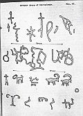
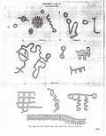
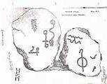
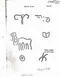
Plate 5, 6, 7, and 8 are small groups located on different parts of the cliff and upon single rocks lying about. These have some very interesting designs some of which were so faint they had to be painstakingly traced with the finger in order to record them. The mountain sheep figures seemed to be the most often repeated, perhaps a record of their hunts.
Plate 14. Showing three mountain sheep, covering a space of 32 inches long and is located 20 feet to the right of the group record on plate 12.
And so, as complete a record as possible was made of this group of petroglyphs now known as the "Swansea Group" in both photographs and drawings. We feel, however, that we would have liked to have spent much more time there.


© 2008The Equinox Project, All Rights Reserved. Compiled from the
contents of The Dawson Library
Created for and maintained by The Equinox Project Please email any comments, questions or suggestions to:
info4u@equinox-project.com
NOTE you must remove !!! from the suplied address before using.
Last Modified January 2010