A Precise Petroglyph Equinox Marker in Eastern California
Alan Gillespie
Department of Geological Sciences 3513F
University of Washington
Seattle, WA 98195-1310
Abstract
Petroglyph site INY272 contains a simple pecked marker consisting of six vertical bars that can be used to predict the time of the equinox, relative to sunset, within 3 hours. This petroglyph works during the week of the equinox. It appears to mark the astronomical equinox, when the angular position (declination) of the sun is half-way between its solstice limits, rather than simply the day-count equinox, or half the number of days between the Summer and Winter solstices. The bars mimic the shape of the edge of a shadow cast by a nearby boulder. The edge sweeps across the petroglyph as the sunsets; its position at the last moment of sunset also moves across the pattern of bars as the sun's declination changes from day to day. It is the position of the shadow relative to the petroglyph bars when the setting sun first touches the horizon that can be read to give the time to equinox with the greatest accuracy. The original determination of the time of equinox may have required only simple tools and observations, but a surprising understanding of the apparent motions of the sun. The age of the petroglyph is at least several hundred years, based on geomorphic evidence, but the people who made it are not known. A radiocarbon age of -2060 14C years for soil CaCO3 may be a minimum age for the equinox marker. If the analysis presented here is correct, the petroglyph is evidence for a high level of calendrical sophistication in antiquity in eastern California.
Introduction
Petroglyphs at site INY272 in eastern California (Heizer and Baumhoff, 1962) comprise a solar calendrical observatory, with rayed circles, spirals, and other patterns evidently marking the times of at least the summer solstice, equinoxes, and possibly cross-quarter days, with distinctive patterns of light and shadow at sunset or sunrise. Some of these patterns are reminiscent of those reported at Chaco Canyon (Sofaer et al., 1979) and elsewhere in the American Southwest. Of primary interest here is one equinox marker, consisting of six vertical bars pecked into the rock, that predicts the actual time of equinox within a few hours.1 This is a remarkable degree of accuracy and precision for an apparently simple device. Although it is difficult to attribute motive and intent to the ancient people who created this petroglyph, it is possible to infer some ways the marker could have been designed, what minimum kit of tools and ideas was necessary to design it, and how closely its use matches theoretical performance limits. The purpose of this article is to investigate these questions.
Site INY272... Petroglyph site INY272 is located at latitude 36.6°N and longitude 11 7.9°W and an elevation of 1130 m, just north of the town of Swansea. The western horizon is formed by the jagged crest of the Sierra Nevada, 30 km distant and rising 3 km above Swansea. There are several hundred petroglyphs at the site, most of which were pecked into white dolomitic marble boulders and bedrock that have been stained tan by weathering. The petroglyphs are concentrated on a wave-polished promontory that was, buried by beach gravels of Pleistocene Owens Lake at the end of the last glaciation, less than 15,000 years ago. The age of the lake high stand was estimated from radiocarbon dating of unaltered clam-shell fossils (Sphaerium striatinum W. Miller III, pers. comm., 1988) from the beach gravels themselves (USGS2626: 12,625±50 14C yr B.P. or -14,800 cal yr B.P.2), and from tufa lower in the stratigraphic section (CAMS-2534: 17,810±90 14C yr B.P. or -21,200 cal yr B.P.). It is consistent with radiocarbon dates of organic matter from lake-sediment cores nearby (Benson et al., 1996). The lake level throughout the Holocene was lower and the promontory has been exposed above shoreline that whole time. The Holocene climate has been arid; modem rainfall is about 10 cm/yr.
Most of the petroglyphs at INY272 were pecked through the tan patina, exposing the white marble beneath. Individual peck marks are about 0.6 cm in diameter and 0.1-0.2 cm in depth. Mary, including those discussed in the present article, were made in the Great Basin Curvilinear Abstract style of Heizer and Baumhoff (1962). In addition to the circles and obvious solar representations, there are several sets of sub-parallel lines or bars. Other petroglyphs have complex geometric forms. Only a few are zoomorphs (mainly sheep) and anthromorphs. Relative weathering characteristics suggest strongly that the petroglyphs were made in several cycles, probably over a period of a thousand years or more. Six generations of petroglyphs are distinguished by differences in patination and erosion, with the oldest markings nearly obliterated. The youngest generation dates from the past hundred years and consists of unweathered graffiti from Anglo settlers and modem tourists.
Many of the petroglyphs were "refreshed" in ancient times, by the same pecking method used to make the originals. Some of these petroglyphs have multiple generations of differently patinated or eroded scars. Refreshing of petroglyphs at INY272 evidently originated early and continued until the historic period. Not all petroglyphs were thus treated, and why certain ones were chosen is not obvious. Raymond Stone, Sr., (Big Pine Paiute Tribe of Owens Valley, CA; pers. comm., 1988) has commented that the modern Indians of Owens Valley did refresh ancient petroglyphs that they considered important.
INY272 has suffered from modem vandalism. The site has been partly quarried, and fly rock has damaged some petroglyphs not totally obliterated. Some of the solar petroglyphs have made attractive bull's eyes for target practice, and vandals have attempted to remove prized panels of petroglyphs using crowbars. Much of the damage has occurred since 1983. In addition, the petroglyphs have been chalked repeatedly to enhance them for photography (see Heizer and Baumhoff, 1962). Because chalk has an organic grease binder, this must be considered if 14C analysis of coatings on the petroglyphs themselves is ever attempted.
Grant (1971) argued that the Great Basin Abstract styles of pecked petroglyphs were the work of Shoshonean people. Historically, Swansea has been near the border between Owens valley Paiute to the north and the linguistically and culturally related Coso and Saline Valley Shoshone to the east and south (Bettinger, 1982; Heizer and Whipple, 1971). Because of the widespread distribution of stylistically similar ancient petroglyphs throughout the Great Basin, it is reasonable to suppose that they were made by long-term residents of the region and not casual visitors, and this view favors the Shoshone as the architects of INY272. However, Raymond Stone did not think that his Paiute ancestors made the ancient petroglyphs at Swansea (pers. comm., 1988), consistent with the earlier findings of Heizer and Baumhoff (1962) that the modem Paiute sometimes attributed the petroglyphs to an earlier non-Paiute people. In fact, we do not now know who made INY272.
If the ancient Shoshone did make the Swansea petroglyphs, there may be some cultural continuity with their descendants, and it is reasonable to interpret the site using modem ethnographic data. Bettinger (1982) cited numerous archaeological dates that show more-or-less continuous habitation of Owens Valley for the last few thousand years. Grant et al. (1968), however, suggested that the Shoshonean people abandoned the area shortly after 500 A.D., only to return much later. Accordingly, even if the people had the same physical lineage, ancient traditions concerning petroglyphs may have been lost (e.g., Heizer and Baumhoff, 1962, p. 203-204), consistent with Stone's claim. Even if Shoshone habitation was continuous, cultural continuity cannot be confidently assumed. Bettinger (1982) argued that there were repeated shifts in subsistence styles in response to changing climatic conditions. These adaptations could have been accompanied by changes in cultural traditions too. Thus, the applicability of the modem ethnography to the ancient Shoshone is uncertain.
Heizer and Baumhoff (1962) believed that most of the petroglyphs in the Great Basin were intended as hunting magic, explicitly ruling out astronomical interpretations. Heizer and Whipple (1971) hardly mentioned astronomical beliefs and knowledge in their summary of California Indians. Although there is a growing literature concerning the astronomical lore of other, non-Shoshonean peoples in California (e.g., Buckskin, 1985; Hoskinson, 1985; Hoskinson et al, In preparation; Hudson, 1985; Williams, 1984), similar ethnographic knowledge has evidently not been developed for the Paiute and Shoshone (e.g., Bettinger, 1982). Considering the rapid increase in documentation of astronomical knowledge of native Americans in general, it is premature to conclude from our lack of knowledge of Shosonean astronomy that they didn't have one, or that they didn't make the calendrical petroglyphs at INY272. Nevertheless, it is safe to say that, even if Shoshonean people made the calendrical petroglyphs at INY272, we now know little about the cultural context in which they were used.
Dating...The calendrical petroglyphs at INY272 clearly predate 1868 A.D., a date carved on the cliff face at INY272 by Anglo settlers (Steward, 1929). The Great Basin Abstract petroglyph styles at INY272 seem to place most of them in the Middle Desert Archaic period (Fagan, 1991), which may have lasted from Ca. 4000 to 1500 BP (Fagan, 1991, p. 237). Heizer and Baumhoff (1962) regarded the Great Basin Curvilinear Abstract style itself to have originated roughly 3000 years ago. These indirect associations suggest but do not prove a similar antiquity for INY272. A preliminary effort to measure a direct, numerical age limit for the petroglyphs at INY272 is summarized in this article for the first time.
Roughly 5 m south of the six-bar equinox marker a line of petroglyphs was partially buried by a shallow mudflow. The petroglyphs above the soil level are weathered and patinated similarly to the equinox marker, and therefore may be of roughly the same age. Below the soil line, a rind of CaCO3 from airborne dust dissolved in groundwater has precipitated on the buried petroglyphs and bedrock alike. The carbon in the dissolved CaCO3 is thought to have the same isotopic signature as carbon in the atmosphere. Therefore, the radiocarbon date may give the age of precipitation, if the climate is sufficiently arid and provided the sample contains no detrital carbonate (Wang et al, 1996). As the mudflow postdates the carving of the petroglyph and the precipitation may occur over a period of many years, and because CaCO3 in the rind may exchange carbon with CO2 dissolved in rainwater (Pendall et al, 1994), the CaCO3 age at INY272 may be a minimum for the age of the petroglyphs. A radiocarbon date on the rind, sampled from the bedrock adjacent to the petroglyphs at a depth of 20 cm, is 2060±60 ~4C yr B.P. (CAMS-25355: 2085-2107 cal yr B.P.). Uncertainties associated with this experimental method of dating, and with correlating the petroglyphs to the equinox marker mean that the results should be regarded as tentative.
Previous Work... Some petroglyphs at INY272 were catalogued first by Steward (1929), and later by Heizer and Baumhoff (1962), but no comprehensive study has yet been published. Fell (1979, 1980) interpreted several petroglyphs as referring to calendrical events, including the vernal equinox. Fell did not visit INY272, but worked from depictions by Heizer and Baumhoff, reproduced from drawings made in 1931 by Clifford Baldwin (Jon Polansky, personal communication, 1985; independently noted by Schmidt, 1992). The depiction in Heizer and Baumhoff is out of context and probably rearranged (Dewald, 1985). Polansky visited INY272 in March, 1979, to look for possible astronomical alignments. In June, 1983, he and I identified the first of several solstice and equinox petroglyphs. Subsequently, Burrell Dawson and Vincent Yoder, both of Lone Pine, California, identified other calendrical features. Schmidt (1993) described some of these discoveries, along with his own.
The original solstice marker, a candidate cross-quarter petroglyph, and the six-bar equinox petroglyph were discussed at the "World Cultures of Ancient America" conference, held at the University of California in June, 1988. An abbreviated analysis of the six-bar petroglyph may also be found in Hoskinson et al (in preparation).
Methodology... A great deal has been written on how archaeoastronomical investigations should be conducted, with warnings on enthnocentrism and other methodological traps. One such "defect," perhaps unavoidable at INY272, is the absence of an ethnological context (Benson and Hoskinson, 1985; Hoskinson et al in preparation). Since this information has not been, or possibly cannot be, developed for INY272, I have focused on a petroglyph that can be analyzed independent of the missing ethnography. Another trap is observation only at a time of interest to the researcher (Zeilik, 1983), or exclusive focus on a petroglyph that "works" rather than sampling all petroglyphs at a site. My observations at INY272 have been made of many petroglyphs at different times of the year for more than a decade. Most "solar" petroglyphs at INY272 do not seem to have unique interplay with light and shadow patterns on pre-determined days of significance such as equinoxes, nor on any other day. This does not mean that the relationships are unimportant.
Below, the calendrical functioning of the six-bar petroglyph is analyzed. Because it "works" at sunset, when the direction of illumination is restricted to a narrow range, the likelihood for mis-interpretation is less than for petroglyphs that interact with light and shadow at arbitrary times of the day. The precision and accuracy with which the six-bar petroglyph can be used to measure the delay between equinox and sunset is determined from direct observation and from computer simulations. The significance of inaccuracies can only be evaluated in terms of the precision. Several hypotheses explaining the observations are evaluated using these data; and the ones which appeared best are selected in subsequent analyses.
Precision is a measure of resolution or repeatability: if one were to measure the shadow edge at sunset several times, or if different observers were to do it at the same time, how closely would the measurements cluster? Accuracy in the present context is a measure of the difference in time as indicated by the petroglyph, and the actual moment of equinox. Differences less than the scatter of measurements due to the basic precision of the marker cannot be resolved. As a measure of accuracy at INY272, I have used the displacement between the sunset shadow edge and the petroglyph center. As justified below, I assume to start with that the shadow was intended to bisect the petroglyph exactly when equinox occurred just at sunset. A certain amount of displacement is expected from the limited precision of the petroglyph; any excess is significant and tells us something about the functioning of the petroglyph. To begin my analysis, I assumed that the petroglyph was intended to function equally well at both spring and fall equinoxes (when the solar declination is increasing or decreasing, respectively).
Observations
In this section four solar petroglyphs are introduced to establish that INY272 was a kind of solar observatory and to set the stage for the presentation of observations on the six-bar equinox calendar. These latter observations concern the petroglyph itself, the shadow cast on it by the setting sun on the days around the equinox, and the daily motion of the shadow. They are analyzed in a subsequent section.
Four Solar Petroglyphs... A few meters northwest of the six-bar petroglyph is a distinctive sun symbol (Fig. 1a). The symbol faces east, but the summer view of the rising sun is blocked by a nearby low cliff. The petroglyph is pecked deeply, in the manner of the majority of markings at INY272. The edges of the peck marks and grooves are only lightly softened by erosion, but the patination is as well developed as on the adjacent bedrock. The petroglyph has not been refreshed recently.
A few meters west of the six-bar petroglyph a prominent "bull's eye" petroglyph on a large boulder is the background for a "sun dagger" light-and-shadow display on the summer solstice (Fig. I b, Plate I). This was the first such feature recognized at Swansea, in June 1983. Close to the solstice, a wedge of light points to the bull's eye at sunset. As the top limb of the sun sinks beneath the horizon ("last sunlight"), the dagger's tip separates from its main part, highlighting the center of the bull's eye. The bull's eye petroglyph shows unmistakably that some of the people who made INY272 were aware of and interested in the solar calendar. Because the daily motion of the sun on the horizon is small at the solstice, the sun dagger can only be accurate to about four days.
Due to changes in the earth's obliquity, the solstice sun 3500 years ago set a solar diameter (0.5°) farther north than it does today. Thus, we are probably not observing the full "sun dagger" intended by its makers. Moving the sunset position a solar diameter at solstice is equivalent to 11 days of motion today. It is readily resolvable on the solstice marker. Thus, it may be that an "astronomical date" for the creation of the solstice petroglyph can be determined, perhaps with an accuracy of about 500 years.
On the southern end of the low bedrock cliff mentioned above is a petroglyph consisting of two bull's eyes, from which radiate short lines, some of which connect the two main features (Fig. I c). Thus, the petroglyph resembles two linked suns. The petroglyph is positioned such that, in May and August, the sun rising over the Inyo Mountains illuminates a part of the upper bull's eye; the lower bull's eye is shadowed by a nearby boulder At sunrise, the west half of the petroglyph is shadowed due to the natural curvature of the bedrock rib on which the bull's eyes are pecked; the result is that only the upper right quadrant of the upper bull~ eye is illuminated, with the horizontal and vertical edges of the illuminated quadrant forming a right angle.
The daily motion of the rising sun on the horizon causes the bottom edge of the illuminated quadrant to lower in May and rise in August, moving across the concentric rings of the bull's eye at a rate of one ring per day. This daily motion forms the basis for a short calendar near the time of the cross-quarter day. The cross-quarter day is the 'half-way point' between each solstice and equinox; there are four such days in a year (the specific ones are dependent upon the definition used). The bull's eye petroglyph is related only to the ones in spring and/or summer.

Figure 1. Solar petroglyphs at INY272, photographed or drawn from photographs taken by the author a) A distinctive east-facing sun symbol. b) A calendrical "sun dagger" active on the summer-solstice sunset (1983). c) The "cross-quarter day" petroglyph at sunrise, August 15, 1985. d) An equinox petroglyph, March 20, 1985. In b-d, sunlight is indicated by light tones and shadows by dark. Petroglyphs are shown by heavy black lines, and natural cracks or other patterns by light black lines.
The cross-quarter day may be defined by the day-count method, in which the number of days between solstice and equinox is divided in two, or by the astronomical method, in which the angle between the apparent position of the sun in the ecliptic (heliocentric longitude) at solstice and at equinox is bisected. There is a day or two of difference between the times thus defined. It is also reasonable to bisect the horizon positions of the solstice and equinox sunrises or sunsets ("geometric" method"). This is roughly the same as bisecting the equivalent solar declinations. The Pit River Indians, in northern California, apparently bisected the angle between the solstice and equinox stations (I.e., geometric method) to represent the cross-quarter day in constructing solar medicine wheels (Buckskin, 1985). May 5 and August 6were the pertinent day-count cross- quarter days in 1996; May 3 and August 5 were the astronomical dates.
The "geometric" dates would have been April 20 and August 20. The discrepancy between the day-count and astronomical dates changes over time because of the precession of perihelion relative to the equinoxes (-21 ,000 -year cycle). About 3300 years ago, for example, perihelion occurred on the fall cross-quarter day, and the day-count and astronomical dates coincided for the spring and fall, but not the summer and winter, cross-quarter days.
Because of irregularities of the Inyo Mountain horizon, there is a distinctive reversal in the daily change in shadow position when it intersects the center of the bull's eye, around April 25-28 or August 12-15. This would be the reasonable time to "read" the intended date, although it corresponds well to neither the day-count/astronomical nor the geometric cross-quarter day. The full explanation of this petroglyph remains elusive. It may be that it was never intended as an accurate calendrical mark if, but just to inaugurate some spring festivity The Mojave to the south, for example, evidently held a dance in early May (Bourke, 1889), shortly after the date marked by the petroglyph.

Plate 1. The summer-solstice petroglyph at INY272, photographed at sunset on the summer solstice, June 1985. a) Before the sun touches the horizon. b) Sun touching the horizon. c) Sun approximately bisected by the horizon. d) At last sunlight.
Figure 1d shows another solar petroglyph that interacts with a right-angle quadrant of light, this one at equinox sunset. It consists of two concentric arcs or incomplete circles, centered about a pecked hole.
The petroglyph, now well-worn and patinated, is on a horizontal boulder, level with the ground. On equinox sunset, and on no other day, shadows cast by a nearby broken fragment of a rock define an illuminated quadrant whose vertex is superimposed over the central hole of the petroglyph. The right-hand edge of the shadow quadrant fits perfectly in the concentric arcs. Although the shadow-casting rock, and possibly the host rock also, appear somewhat less stable than the other markers at this site which are set in bedrock, the apparent fit suggests that no substantial movement or rotation has occurred. The petroglyph itself has no obvious solar symbolism, but the interplay of light and shadow on the equinox sunset seems to be too precise to be accidental. Thus, this petroglyph reinforces the conclusion that INY272 was used as some kind of solar observatory, and shows clearly that the petroglyph-makers were attuned to the equinoxes as well as the summer solstice.
The Six-Bar Equinox Petroglyph... The equinox marker consists of six nearly vertical bars pecked on a southwest-facing, sloping bedeck face (Fig. 2a). It is about 26 cm wide at its base, 21 cm wide at its top, and 12 cm high. The individual bars are about 2.3 cm wide and 1.8 cm apart. The six-bar petroglyph may have been refreshed at least once. The peck marks are more patinated than are the ridges separating them. A little over 2 m to the west is a V-shaped notch formed by two large rocks (Fig. 2b). Within three days of the equinox, and only then, the sun setting behind the Sierra Nevada casts a shadow from the northern of the rocks onto the petroglyph (Fig. 2c). The shape of the shadow coincides closely with the Inner vertical bars of the petroglyph, although the match is only approximate for the outer bars (Fig. 2d). A natural protuberance or "nose" interrupts the otherwise linear edge of the shadow, which is closely paralleled by the pecked bars. As the sun sets, its azimuth increases and its elevation angle decreases, causing the shadow edge to sweep from north to south across the petroglyph, and the "nose" of the shadow to rise. The shadow moves south one bar per day at the vernal equinox, and north at the autumnal equinox. On the equinox, the shadow bisects the space between the two central bars, which alone of the six ate connected by a short horizontal spacer, forming a crude "H." On that day, as the sun disappears the shadow "nose" fits into a natural groove below the six bars. When the setting sun is south of its equinox azimuth, the "nose" is below the shallow groove; when the sun is north the "nose" Is above it.
The time during the day of the actual moment of equinox varies from year to year. The shadow edge is offset to north or south by an amount proportional to the delay between the equinox and sunset.
Because the sun subtends -0.50 as viewed from Earth, shadows have "fuzzy" edges (penumbra). As the sun sets, shadow edges sharpen because less of the sun's disk remains above the horizon. Simultaneously, sunlit surfaces darken, while shadowed surfaces - illuminated by the sky - do not. Therefore, shadows become sharply delineated but faint. The interplay between shadow sharpness and contrast limits the precision with which the shadow position can be marked. Uncertainties in the location of the shadow, the moment at which the shadow is to be "read," and the edges of the petroglyph bars compound to limit the fundamental precision of the marker as a calendar: To calculate this precision, the measurements in space and time must be related by the speed of the shadow sweeping across the petroglyph. Below are presented the necessary observations on the precision with which: 1) the shadow edge can be located; 2) "last sunlight" can be determined; 3) the edges of the petroglyph bars can be located; and also the speed of the shadow moving across the petroglyph. In the next section, the above spatial uncertainties will be compounded and converted to errors in "clock time" in determining the equinox.
On the six-bar petroglyph, the width of the penumbra measured with a densitometer on photographs narrows from 2.6 to 1.1 cm as the sun sets. In a blind experiment, ten untrained observers examining the same photographs marked the shadow edge near the center of the penumbra, with a repeatability (precision) of ±0.4 cm when the sun was above the horizon. A single observer was more consistent (±0.2 cm). Although a trained, experienced observer could probably do better still, especially with the sharper shadow edge as the sun sets, the single-observer precision is used below.
Measurement in the field under clear atmospheric conditions suggests that the time at which the shadow vanishes (at "last sunlight") can conservatively be marked within ±3 s. For reference, ephemeris calculations indicate that 84 s separate first and last contact of the setting equinox sun with the horizon. This figure is slightly less than would be observed, due to "blooming" of the solar disk caused by the scattering of light by the atmosphere.
The individual pecked marks comprising the petroglyph are typically 0.6±0.2 cm in diameter. The edges of the petroglyph bars are straight within roughly a range of 0.4 cm. In practice, however the shadow edge is not marked against individual peck marks, but against the edge of the bar over a distance of 1 cm or more. Over this distance, the edge of the bar is probably locatable within 0.2 cm.
The shadow in the minutes before sunset sweeps across the petroglyph at a rate of 1.6 cm/mm. The daily motion of the shadow edge at sunset Is 4.1 cm, the same as the average width of a bar and the adjacent space.
The locations of the edge of the shadow at last sunlight, measured from photographs and videos taken 1983-1995, are given in Table I and are plotted against the time from equinox in Figure 3. Because multiple measurements were made at about the same time from equinox on different occasions, it is possible to obtain a direct measure of precision of about ±0.5 cm or less horn Figure 3; that is, for a given time difference between sunset and equinox, the shadow edge will be marked conservatively to the same location within ±0.5 cm.
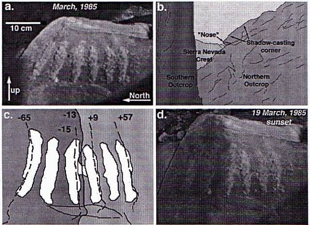
Figure 2. The equinox calendar a) Photograph of the six-bar petroglyph, taken a few minutes before sunset, March 19, 1985. b) The boulder corner (right) that casts the equinox sunset shadow, viewed from the six-bar petroglyph against the background of the distant Sierra Nevada. The height of the pass of the "southern outcrop" shown, actually another boulder, is -1 m. Drawn from a photograph taken looking along azimuth 266° horn base of petroglyph. The shaded area of the "nose," shown schematically, was damaged by vandals. c) The six-bar petroglyph panel and sunset shadow edges at last sunlight, shown by the heavy solid (9123/91) and dashed lines (9/19/92,3/19/85,3/20/85, and 3/22~ 85, from left to right). In each case, the shadow extends left (north) from the shadow edge, as shown by the shading. Numbers near the lines are the number of hours from equinox. Negative times indicate that the sun set south of its equinox position. Shallow horizontal groove into which the "nose" shadow fits at equinox sunset is shown below the petroglyph. Illustration was traced horn a photograph. Shadow positions were sketched free-hand from photographs and videos and are somewhat generalized and schematic. Some variability in shadow location was noted under different atmospheric conditions. d) Photograph of the petroglyph arid sunset shadow a few seconds before last sunlight, March 19, 1985.
The "nose" of the shadow-casting rock was broken and discarded by vandals in Ca. 1989. In 1995, it was found a short distance away. It can be fitted back into the damaged shadow-casting rock. Observations for this study made in 1983-1989 are unaffected, but for observations after Ca. 1989 the shadow position on the center line of the petroglyph must be estimated from the shadow of the undamaged rock above the nose. This requires extrapolation on the six-bar petroglyph of -2 cm.
Analysis
It seems likely that the six-bar petroglyph was actually meant as an equinox calendars because of the other solar and calendrical petroglyphs at INY272, because the bisecting of the six bars at equinox sunset, and because the coincidence of the bar spacing and the daily motion of the last-sunlight shadow seem too perfect to be accidental. Hypothesizing that the bars and gaps were intended to mark days around the time of equinox, I used an ephemeris program (Duffett-Smith, 1981), a topographic map, and measured orientations and positions of the petroglyph and the shadow-casting rock to predict shadow positions over time. The topographic map was used to calculate the elevation angle vs. azimuth for the western horizon as viewed from INY272, making allowance for the Earth's curvature. The ephemeris was used to calculate the position of the top of the sun, because the azimuth at last sunlight was taken to be the time to "read" the petroglyph. A small correction must be made for refraction due to the atmosphere. This correction, at the elevation of Swansea and with an horizon elevation angle of 50, is a third of the solar diameter. The goal of this simulation was to predict the performance of the six-bar petroglyph as an equinox marker, for more equinox sunset azimuths than could be observed directly in a few years. For the direct observations that have been made, the correspondence between the observed and predicted shadow positions is quite good (r2>0.97), and it follows that the computer simulation is accurate for equinoxes of other years as well.
The six-bar petroglyph is "read" by measuring the sunset shadow position against the backdrop of pecked bars. When multiplied by the average daily last-sunlight shadow motion of 4.1 cm, the uncertainty in shadow location (±0.5 cm) translates to a calendrical precision of ±3 hours. Because few repeat observations were available, however, this figure itself may be unreliable. As a verification, it is also possible to calculate the overall precision from the separate uncertainties of the shadow measurement, the moment of last sunlight, and the positions of the pecked bars, as discussed in the previous section. These uncertainties are independent of each other and random: for example, the exact moment at which the petroglyph is "read" at sunset is unrelated to the location of the reference pecked bar, and the respective uncertainties are also unrelated. Thus, the overall precision must be estimated by "compounding" the individual uncertainties.'
The compounded uncertainties in marking the edge of the shadow relative to the petroglyph at last sunlight are about ±0.24 cm, or ±9 s. At 4.1 cm/day, this corresponds to a calendrical precision of ±54 minutes. Because this value is only halt 01 the more direct estimate, it seems likely that not all the sources of uncertainty have been correctly identified or measured. Therefore, the more conservative, but still remarkable, value of ±3 hours is accepted here. This precision results from the natural characteristics of the site itself. Of the factors under control of the petroglyph makers, the shape and sharpness of the bar edges have the biggest effect on the precision. The high precision need not have been intended nor even recognized; nevertheless, it can be used to test the accuracy of the petroglyph as an equinox calendar, and to gain some insight into the actual use of the petroglyph and the reasoning behind its construction.
Figure 3 shows that the shadow edge at last sunlight does not bisect the central bars exactly when the equinox coincides with sunset. A second-order polynomial least-squares fit to the measured shadow positions shows that the center is bisected when the vernal equinox precedes sunset by about 8 hours. Equivalently, when equinox occurs at local sunset, as occurred on September 22, 1993, the shadow is about 1.7 cm south of the petroglyph center. These times and distances are easily resolved by viewers of the petroglyph, and the implied inaccuracy is real: the petroglyph doesn't seem to "work" as well as it could, at least if it is read at last sunlight.
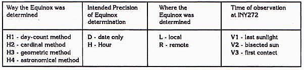
The equinox may have been defined one of four ways at INY272 (Table 2): (HI) counting days from one of the solstices (day-count method); (H2) measuring the sunset azimuth against an east-west line (cardinal method: see Hoskinson, 1985); (H3) bisecting the angle between the winter and summer solstice sunset positions (geometric method); (114) measuring the solar declination (astronomical method). Additionally, there are variants of each method: determining the time of equinox to the nearest day (D) or more precisely (T), at INY272 (L) or elsewhere (R), and measuring the shadow position on the six-bar petroglyph at last sunlight (Vi), when the horizon bisects the setting sun (V2), or at first contact of the setting sun with the horizon (V3). Below, for brevity these hypotheses will be referred by their letter assignments: "H4/T/R/V1," for example, denotes the astronomical method, timing determined elsewhere to a fraction of a day with the petroglyph "read" at last sunlight; MH4/V1" would denote the same method with the petroglyph read at last sunlight, but with the location of the timing measurement and its precision unspecified. Each method leaves a characteristic signature in the performance of the petroglyph. For example, there is now a one- or two-day discrepancy between the day-count equinox and the true equinox, due to the eccentricity of Earth's orbit. Thus, on the day-count equinox the sunset shadow falls in the southernmost gap of the petroglyph, not in the center gap. Even accounting for the precession of perihelion and the equinox, the day-count and true equinoxes have been in substantial disagreement for the past 5000 years. Therefore, it is unlikely that any variant of hypothesis HI is valid, provided the basic assumptions in this analysis are correct.
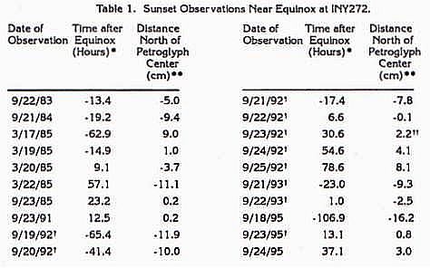
* Time after equinox of local sunset is calculated for INY272 using an ephemeris (Duffett-Smlth, 1981) and has been rounded off to the nearest hour.
** The distance is measured photographically to ±0.2 cm (see text)
Photograph/video courtesy of R. L Schmidt, Lone Pine, CA.
Shadow position may have been affected by atmospheric haze.
Table 2. Hypotheses About the Construction of the Six-Bar Equinox Petroglyph at INY272.
The sun at INY272 sets due west a week after the true vernal equinox, due to the elevated local horizon (elevation angle >50): the shadow then is "off scale" to the south. Thus, H2/L cannot explain the accurate working of the six-bar petroglyph. However, measuring the sunset position against a level east-west line (elevation angle 0°) established elsewhere would have reduced the discrepancy between the shadow position and the center of the petroglyph. In this explanation (K2/R), the "news" of the equinox would somehow have been carried to INY272, whereupon the sunset shadow positions would have been noted and incorporated into the petroglyph. Hoskinson (1985) determined that the east/west reference line could be determined within -0.2° using observations of near-noon shadow positions and simple tools. Compounding this additional uncertainty with the uncertainties already accounted for would give a total of -6 hours for H2.
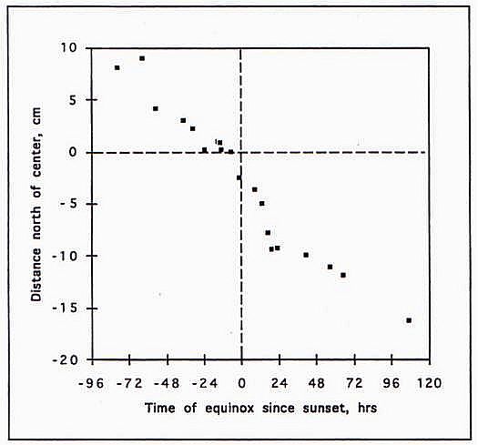
Figure 3. Locations of the shadow edges at the last moment of sunset (last sunlight), plotted against the time from equinox (for negative times the sun sets north of its equinox position on the horizon).
A reasonable location for observation of the level horizon would have been the crest of the Inyo Mountains, just east of INY272. There, the sun sets due west when sunset precedes the vernal equinox by a little less than 20 hours, due to atmospheric refraction. The shadow position then is a little less than 2 cm north of the petroglyph center. These errors are much larger than the observed inaccuracies; thus it appears unlikely that H2 is correct.
Complex variations of H2 can be imagined, and not all can be ruled out. For example, the ancient sunwatchers could have observed the rising sun from the crest of the Inyo Mountains: the sun would rise due east 20 hours before the vernal equinox but sunset, 12 hours later, would occur only 8 hours before the equinox, such that the shadow would be north of the petroglyph center by just the amount observed. However, the sun would rise due east 20 hours after the autumnal equinox, and the pet~g1yph would not work then.
In the geometric method (H3) the horizon positions of the solstice sunsets must be marked and the angle formed by them and a central pole must be bisected to predict the equinox sunset azimuth. Overall precision is probably similar to H2. For the ragged horizon formed by the Sierra Nevada, the predicted equinox azimuth is -0.8° of arc north of Its actual position when sunset and equinox coincide. This corresponds to an error of -36 hours, and H3/L can be confidently rejected. On the other hand, the geometric method can be accurate for a level (or nearly level) horizon, and H3fT/R is therefore a valid explanation.
The astronomical method presumes that somehow the sunwatchers were able to measure or infer the position of the sun against the stellar background, and therefore to determine the moment of equinox, when the solar declination is 00. If they could determine this moment accurately and precisely, H4/Vl must be rejected, because the inaccuracy of 8 hours is greater than even the 2-cy (95%-confidence) uncertainty of 6 hours.
This rejection of H4 assumes that the shadow was measured at last sunlight (H4/V1). The prevalence of solar symbols at INY272 that axe bisected or quartered by light patterns suggests another possibility: if the critical moment was when the setting sun was bisected by the horizon, 42 seconds before it disappears, the curve of Figure 3 would be shifted about 1.1 cm to the north. This would reduce the inaccuracy to -4 hours for H4/V2. Reading the petroglyph at first contact (H4/V1) would further reduce the error to zero. However, there is no compelling reason to assume that the moment of observation was at first contact, or when the setting sun was half-way down. How would the ancient astronomers have observed the bright disk of the sun, and how repeatably could they have marked this time? Even If first contact or the "half-down" moment could only be identified within ± 15 s, a conservative value, the fuzzy shadow location still is the dominant source of uncertainty, and the formal compounded error is now close to the ±3 hours actually determined for Vi.
Reading the shadow position at V2 or V3 would have no effect on the rejection of I-U. Reading the sun at VI, however, would counter the 20-hour error caused by refraction of the setting sun in method H2. In principle, at least, H2/T/R/V3 could time equinox accurately, with a precision of -6 hours. Lastly, method H3 is insensitive to the time sunset is marked, provided it is marked consistently.
Discussion
Methods H2/T/R/V3, H3/T/R/VI -V3, and H4/T/ (R,L)/V2-V3 all explain the data for the six-bar petroglyph satisfactorily. Which one is the most likely? One way to judge would be to assess the difficulty of implementing each method. There are three important questions: 1) How could the maker recognize the day of equinox? 2) Did this information have to come from elsewhere, or could it have been generated locally? 3) How could the maker have recognized when the equinox occurred just at sunset?
Method H2/T/R/V3 requires an east/west line, which can be constructed with a minimum tool kit of sticks, plumb bobs and string. Hoskinson (1985) describes in detail how this can be done, and Hoskinson et at. (in preparation) report that east/ west reference lines were constructed in the Gila River region, using these techniques. The method demands that the elevation angle of the horizon is 00, and this requires some kind of level to determine. A bowl filled with water is sufficient. Therefore, 112/ T/R/V3 is feasible; the chief hurdle is the conceptual one of understanding the need for a level horizon.
Method H3/T/R/V1 -V3 requires the same tools as H2/T/R/V3. it is also necessary to understand how to bisect an angle but, once conceived, this is simple task with the minimum tool kit.
Method H4/T/R requires only that the knowledge of the equinox be imported from elsewhere, most reasonably from the great astronomical centers in meso-America or their outposts.
Method H4/T/L requires the greatest sophistication on the part of the local sunwatchers. The difficulty is in determining when the declination of the sun is zero as it sets. The easiest way to determine when the declination is zero requires measuring the elevation angle of the sun at noon, a simple task similar to constructing the east/west line. When the sun crosses the equatorial plane, a simple trigonometric relationship exists between the height of the sighting pole and the length of its shadow for the noontime sun and a similar triangle for the pole star, or for the axis of rotation of the night sky. Determining accurately when equinox occurs at sunset may require either a theoretical correction to the noon measurements or stellar observations and is not simple in practice.
If the equinox occurs exactly at noon, then by sunset 6 hours later the declination is about 0.125° (spring) or -0.125° (fall). Thus, if the shadow edge at last light were recorded at last sunlight on the day of the vernal equinox, the edge would be south of its "correct" position by close to the observed amount. However, on the autumnal equinox the shadow edge would be off to the north by a similar amount, and this is not observed. Perhaps the shadow edge was recorded fortuitously on the vernal equinox, or was chosen to mark this event. The petroglyph, however, provides no evidence on these points.
In evaluating the solar petroglyphs at INY272, it is necessary to remember that eastern California is seismically active, and that the entire site may have sunk or been raised a few meters or rotated a degree or two in the past. Individual boulders especially would be vulnerable to movement during intense shaking. The last major earthquake, in 1872, ruptured the ground from Owens Lake north through the town of Lone Pine to the town of Big Pine, a distance of 100 km; contemporary reports from Swansea indicated that some displacement may have occurred and shaking there was strong enough to level dry-wall structures, although it was much weaker than at Lone Pine (Likes and Day, 1975, p. 32). The previous earthquake on the same fault must have been 5000-7000 years ago (Bierman et al, 1995), probably before the petroglyphs were made. Clearly, tectonic subsidence and shaking are sources of uncertainty in analyzing the petroglyphs atINY272; however, the remarkable accuracy of the six-bar petroglyph argues that the cumulative effects have fortuitously been negligible.
Conclusions and Implications
Based on the data and interpretations discussed above, it appears that the unknown makers of the six-bar petroglyph at INY272 could have used sunset observations to predict the day of the astronomical equinox, when the sun crosses the equatorial plane, up to three days in advance, It is also possible to use the marker to predict the time of equinox, relative to sunset, within about ±3 hours. That the sunset marker works this well, despite the irregular, elevated horizon, is evidence against simple coincidence and in favor of a sophisticated knowledge and intent of its makers. These ancient astronomers were not simply counting days from the winter or summer solstice to estimate the time of equinox, nor were they just marking the time the sun set due west as viewed from INY272. It is clear that surprisingly precise and accurate calendrical predictions could have been made in North America before recent European contact.
However, the only evidence pointing towards the astronomical sophistication of the makers is the functioning of the petroglyph itself~ devoid of any ethnographic context or other independent lines of evidence, and the petroglyph is ambiguous on this point. It is clear that the sunwatchers could have designed the six-bar petroglyph in a number of ways that perhaps required a generalized appreciation of the yearly motions of the sun, but not a detailed knowledge of the pertinent orbital mechanics as we now conceive of them. For example, the geometric bisecting of the solstice sunset azimuths could have been done on purely religious or esthetic grounds. This explanation, however requires the sunwatchers to have made the horizon observation far from INY272, and imported the timing information. Why would they go to this trouble? If this method was the one used, the sunwatchers must have had a theoretical, abstract concept of the solar cycle they were trying to record in stone, and for some reason INY272 was the place to do it, even though flatter localities may have been easier to use.
In the end, the best explanation for INY272 cannot be definitively established from the data now available. I regard H3/R and H4/L as the most reasonable hypotheses at the present time. In other words, it seems likely that the sunwatchers were either marking the moment when sunset occurred exactly halfway between the summer and winter standstill positions, or marking the sunset position following the noon when the elevation angle of the sun was halfway between its noontime solstice extremes.
Evidence for or against these possibilities may someday be developed from the presence or absence of similar accurate and precise calendrical sites elsewhere in the Great Basin and its surroundings. Preliminary findings suggest that there are at least three such sites, widely distributed and probably made by different peoples (1-loskinson et al. in preparation).
The six-bar petroglyph at INY272 could have been constructed using only locally available tools. Generalized knowledge of the yearly motions of the sun must have been common; however, the sophisticated understanding of the nature of the equinox suggested by the performance of the six-bar petroglyph and the astronomical explanation (H4/L or H4/R) raises the question of the source of this understanding. It is reasonable to speculate that some of this knowledge could have diffused widely from the great astronomical centers of pre-Columbian Meso-America. Hopi and Pima/Papago oral traditions, for example, maintain that their ancestors migrated south through Mexico, and then returned to New Mexico and Arizona after a long period of time (e.g., Saxon and Saxon, 1978; Russell, 1980). The Hopi probably arrived in their present territory ca. 1100 A.D.; the Pima/Papago even later Therefore, the chronicled journeys are probably not the ones that brought the astronomical knowledge that inspired INY272 but similar, earlier travels could have been. The Pueblo ancestors did leave solar calendar markers similar to those at INY272, although those that we know of appear to have postdated INY272. Zapotec astronomical sites In Oaxaca, on the other hand, are thought to date to Ca. 2000 years B.P. (Meluzin, 1987-88), and must have been based on yet older knowledge possibly contemporaneous with INY272. These conjectures are just that; from the slim evidence developed at INY272, It is not possible to choose among them, nor is the list of possibilities complete.
Equinox sites are potentially sensitive chronometers because the sun's declination changes quickly, in contrast to the solstices when it changes little. Equinox sites, however, offer no opportunity for dating by archaeoastronomical methods (McGlone et al, 1993, pp. 199-201). At Swansea, some petroglyphs are "active" on the summer solstice, and near cross-quarter days. One or more of these features may offer an opportunity to estimate a date of construction based on the gradual change in the earth's obliquity. Preliminary calculations suggest that the solstice marker of Plate I could yield a maximum archaeoastronomical age with a precision of -500 years.
It is of interest that the calendrical petroglyphs were first investigated as a result of Fell's epigraphic interpretation of the site. However, since INY272 fits well within the Desert Archaic styles described elsewhere, findings cannot be used to verify all of Fell's conclusions. Although it is best to leave open for now the question of who actually constructed this remarkable site, progenitors of the people who lived there at the time of Anglo contact are viable candidates. The Paiute and Shoshone people who lived and still live near Swansea have not been credited with a sophisticated knowledge of astronomy by their ethnographers. Information from INY272 suggests that this view may be naive.
Acknowledgments
The U. S. Geological Survey performed conventional 14C dating on clams; the AMS 14C date on soil carbonate was done at the Lawrence Livermore National Laboratory under the guidance of John Southon. William Miller III typed the clam fossils, and Tracy Furutani evaluated their degree of alteration. Jon Polansky has been a valued colleague in this and other adventures over the years. Special thanks are due to Burrell and Margaret Dawson, and to Robert Small. Elsa Abbott and Fred Budinger, Jr., lent a hand in the field. Vince and Anne Yoder and Rod Schmidt generously shared their own observations and thoughts on INY272. Rollin Gillespie was an inspiration in the orbital mechanics. The manuscript benefited from critical reviews by Donal Buchanan, Tom Hoskinson and Jon Polansky. Geological aspects of this study were supported by NASA.
Footnotes
1 Throughout, uncertainties are given as ±1 standard deviation (1 a) unless otherwise noted.
2 Radiocarbon dates 14C yr B.P.) do not correspond exactly to "true" or astronomical dates, because the production rate of 14C in the atmosphere Is not constant. Stulver and Relmer (1993) developed a calibration curve that converts radiocarbon dates to calibrated dates (cal yr B.P.) which correspond more closely.
3 Compounding errors Is done by taking the square root of the sum of the squared precisions: If a~b+c, end b and c are measured within ±ab and ±a~, the precision of a is a~ =
References Cited
Bierman, P. B., Gillespie, A. R., and Caffee, 1k, 1995, Cosmogenic age estimates for earthquake recurrence intervals and debris-flow fan deposition, Owens Valley, California. Science 270: 447-450.
Benson', A., and Hoskinson, T., 1985, Preface. In A. Benson and T. Hoskinson, eds., Earth and Sky, Proc. Northridge Conf. on Archaeoastronomy, Slo'w Press, Thousand Oaks, CA, p. vii-ix.
Benson, L. V., Burdett, J. W., Kashgarian, M., Lund, S. P., Phillips, F. M., and Rye, R. 0., 1996, Climatic and Hydrologic Oscillations in the Owens Lake Basin and Adjacent Sieira Nevada, California. Science 274: 744-749.
Bettinger, R. L, 1982, Archaeology East of the Range of Light: Aboriginal Human Ecology of the Inyo Mono Region, California. Monographs in California and Great Basin Anthropology, No. 1, Davis, CA.
Bourke, J. G., 1889, Notes on the Cosmogeny and Theogeny of the Mohave Indians of the Rio Colorado, Arizona. Reprinted in R. F Heizer, ed.,
A Collection of Ethnographic Articles on the California Indians, 1976, Ballena Press Pubi. In Archaeology, Ethnography and History No. 7,77,97.
Buckskin, F., 1985. Racing Simlek's shadow. In A. Benson and T. Hoskinson, eds., Earth and Sky, Proc. Northridge Conf. on Archaeoastronomy, Slo'w Press, Thousand Oaks, CA, p. 49-54.
Dewald, L. J., 1985, The Inyo, California, zodiac. ESOP14 (#377).
Duffett-Smith, P., 1981, Practical Astronomy with your Calculator, Second Edition. Cambridge U. Press.
Fagan, B. M., 1991, Ancient North America, The Archaeology of a Continent Thames and Hudson.
Fell, B., 1979, An ancient zodiac from Inyo, California. ESOP8:1, 9-14.
Fell, B., 1980, Saga America, Times Books, New York, p. 173.
Grant, C., 1971, Rock art in California. In R. F. Heizer and M A. Whipple, eds., The California Indians: A Source Book. U. California Press, 2nd ed., p. 231 -243.
Grant, C., Baird, J. W., and Pringle, J. K., 1968, Rock Drawings of the Coso Range Maturango Museum Pub. No. 4, China Lake, CA.
Heizer, R. F., and Baumhoff, M. A., 1962, Prehistoric Rock Art of Nevada and Eastern California. U. California Press.
Heizer, R. F., and Whipple, M. A., 1971, The California Indians: A Source Book. U. California Press, 2nd edition.
Hoskinson, T., 1985, Shadows of Kakunupwama: Cycles of the equinox sun. In A. Benson and T.
Hoskinson, eds., Earth and Sky, Proc. Northridge Conf. on Archaeoastronomy, SIo'w Press, Thousand Oaks, CA, pp. 55-64.
Hoskinson, T., Polansky, J., and Gillespie, A., In preparation, Calendrical Precision at Equinox Sites: Apparent Roles for Both Ritual and Science. Proc. Utah Rock Art Research Assoc.
Hudson, T., 1985, Skywatchers of Ancient California. In A. Benson and T. Hoskinson, eds., Earth and Sky, Proc. Northridge Conference on Archaeoastronomy, Slo'w Press, Thousand Oaks, CA, p. 41-48.
Likes, R. C., and Day, 0. R., 1975, From This Mountain - Cerro Gordo. Chalfont Press, Bishop, CA.
McGlone, W. R., Leonard, P. M., Guthrie, J. L., Gillespie, R. W., and Whittall, J. P., Jr., 1993, Ancient American Inscriptions: Plow Marks or History? Early Sites Res. Soc., Sutton MA, p. 80-84.
Méluzin, S., 1987-88, An ancient Zapotec calendrical Cosmogram. Archaeoastmnomy X, 139-147.
Pendall, E. 0., Harden, J. W., Trumbore, S. E., and Chadwick, 0. A., 1994, Isotopic Approach to Soil Carbonate Dynamics and Implications for Paleoclimatic Interpretations. Quaternary Res. 42: 60-71.
Russell, F., 1980. The Pima Indiana Re-edition of the 1908 publication with Introduction, Citation Sources, and Bibliography by Bernard L. Fontana. U. Arizona Press, Tucson.
Saxon, D. and Saxon, L., 1978.0 othham Hoho ok A agitha, Legends and Lore of the Papago and Pima Indians. U. Arizona Press, Tucson.
Schmidt, R. L., 1992, Swansea, a Multicultural Petroglyph Site in Inyo County, California. ESOP21, 268-276.
Schmidt, R. L., 1993, Swansea, a Multicultural Petroglyph Site in Inyo County, California, Part 2. ESOP22,267-272.
Sofaer, A., Zinser V., and Sinclair R. M., 1979, A Unique Solar Marking Construct. Science 206: 283-291.
Steward, J. H., 1929, Petroglyphs of California and Adjoining States. Univ. California Pubis. American Archaeology and Ethnography, Vol 24(2), Berkeley and Los Angeles.
Stuiver, M., and Reimer, P. J., 1993, Extended '4C Database and Revised CALIB Radiocarbon Calibration Program. Radiocarbon 35: 215-230.
Wang, Y., McDonald, E., Amundson, R. McFadden, L, and Chadwick, 0., 1996, An Isotopic Study of Soils in Chronological Sequences of Alluvial Deposits, Providence Mountains, California. Geol Soc. Am. BulL 108: 379-391. Williams, R. A., 1984, Living the Sky. Houghton Mifflin, Boston.
Zeilik, M., 1983, One Approach to Archaeoastronomy: An Astronomer's View. Archaeoastronomy 6:4-7.